


CHartreuse Mont Rachais 2 chemin inconnus

c.gourme
User
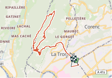

Length
15 km

Max alt
1043 m

Uphill gradient
966 m
Km-Effort
28 km

Min alt
224 m

Downhill gradient
970 m
Boucle
No
Creation date :
2021-08-10 07:47:12.0
Updated on :
2021-08-10 14:54:15.316
6h12
Difficulty : Easy

FREE GPS app for hiking
 SityTrail
IGN / Geographical institutes
SityTrail Plus
The world is yours!
About
Trail Walking of 15 km to be discovered at Auvergne-Rhône-Alpes, Isère, La Tronche. This trail is proposed by c.gourme.
Positioning
Country:
France
Region :
Auvergne-Rhône-Alpes
Department/Province :
Isère
Municipality :
La Tronche
Location:
Unknown
Start:(Dec)
Start:(UTM)
715991 ; 5009295 (31T) N.
Comments